


LOSS PREVENTION
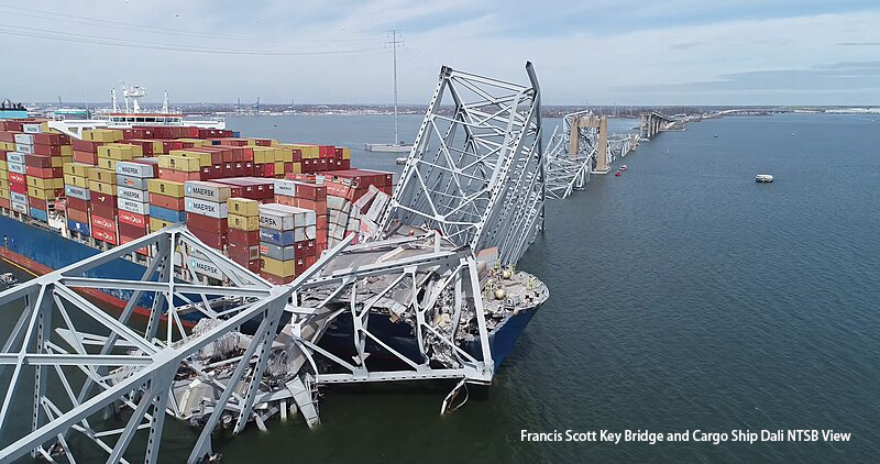
LP 12/2024 Timeline to Reopen Port of Baltimore Remains Uncertain
USCG has verbally advised that it will be a minimum of 2 weeks before any port movements resume, how...
LP 05/2024 Turkey Intensified Penalties for Drug Smuggling
It is common practice in Turkish jurisdiction to consider crew members as suspects of the crime if d...
LP 02/2024 Increased Tariff for Pollution at Sea in Turkey in 2024
The tariff for pollution incidents in Turkiye has been revised with the rates to be applied in 2024 ...
LP 01/2024 Update on the Red Sea and Gulf of Aden Security Situation
10 more incidents were reported in the Red Sea and Gulf of Aden since December.
2023-09
Search
Despite continuous notices from P&I Clubs on the risk of detention when anchoring the Eastern OPL off Singapore, the Association has observed increased reports of detention by the Malaysian or Indonesian administration over alleged illegal anchoring offences. While it is a common occurrence for the masters to get confused with the area of territorial waters, the enforcement measures by the coastal states have added greater uncertainty. In this regard, we would like to remind Members intending to anchor their vessels in the EOPL to carefully assess the location.
I. Positions of anchored ships
Compared to the situation in early 2021, most ships off the EOPL choose to anchor outside Malaysian and Indonesian territorial waters with a small portion anchoring inside.
II. Malaysian detentions
According to the Malaysian Maritime Enforcement Agency (MMEA) official, an oil tanker and a cargo ship were most recently detained on 31 January for investigation under Section 491B(1)(I) of the Merchant Shipping Ordinance 1952. The cargo ship was discovered at 30.7 nautical miles east of Tanjung Sedili, quite close to the alleged Malaysian territorial sea borders.
According to the Johor MMEA press release on 26 September 2021, 83 ships were detained as part of Operation “Op Jangkar Haram” which began on the 24th of March. 18 ships were detained in early 2021 before the operation and 14 afterwards, meaning a record high of 115 ships were detained for illegal anchoring in the entire 2021.
In addition, the waters between Pulau Pinang and Pulau Klang north of Malaysia by the Straits of Malacca have seen strict MMEA enforcement and hence many ship arrests.
The MMEA generally detains ships that fail to give notifications to the Malaysia Director of Marine under Section 491B of the Merchant Shipping Ordinance 1952 and the Malaysia Shipping Notice 05/2014. Malaysia ratified UNCLOS 1982 on 14 November 1996, and through the Baselines of Maritime Zones Act 2006 and the Territorial Sea Act 2012, declared to employ straight baselines and a territorial sea breadth of 12 nautical miles. While Malaysia has not yet formally established its baselines, a 1979 map that sets out the limits of the Malaysian territorial sea is used by the enforcement agency for jurisdictional purposes. Yet the outer limit of the territorial sea is considerably more than 12 nautical miles at some points, and ships are often detained for mistakenly entering the alleged territorial waters.
III. Indonesian detentions
Indonesia has not disclosed the exact number of detained vessels like Malaysia, but news and correspondent reports have indicated a recent increase in incidents of detention. Lloyd’s List Intelligence reported in November 2021 that more than 25 shipowners in the last three months had made payoffs to release vessels held by the Indonesian navy so that not to be tied up for 6-8 months before the case is heard in court. An Indonesian Rear Admiral, while denied such payment in a written response, confirmed that an increasing number of ships had been detained in the past three months for anchoring without permission in Indonesian waters, deviating from the sailing route or stopping mid-course for an unreasonable amount of time.
According to Indonesian Shipping Law No. 17/2008, Indonesia reserves coastal trade for Indonesian-flagged vessels, requiring that domestic sea transportation, including barging, cargo operation, provisioning, crew replacement, etc., are only carried out by Indonesian shipping companies using Indonesian-flagged vessels and crews of the Indonesian nationality; any vessel not engaged in an innocent passage within the territorial waters of Indonesia needs to obtain clearance from the relevant authorities. Although Indonesia has established its baselines for territorial waters, some vessels were detained by the navy as far away as 60 nautical miles from the coastline, which ar believed not in Indonesian waters.
Indonesian’s Directorate General of Sea Transportation (DGST) issued KM30 on 3 February 2021, establishing two anchorage areas in the waters east of Pulau Bintan and requiring all ships to seek approval before conducting any activities in the designated area. However, these two anchorages are not marked out on the charts used by most merchant vessels, and part of an anchorage is located outside the territorial sea boundary. Many ships are hence detained as the crew may have mistaken the designated area for international waters
IV. Advice to Members
The arrested ship and its master would generally go through a lengthy process before being released, especially in Indonesia where it may take months for a final decision to be made by the local court. The Association, therefore, would like to alert Members operating off the EOPL to be cautious with the risk of detention. The following actions should be considered at least.
- The master, before anchoring, should ask the company or agent about information regarding the territorial limits and designated areas, including the Peta Sempadan Perairan Pelantar Benua Malaysia (1:1,500,000)-No.Siri Rampaian 97, the geographical coordinates points of the Indonesia Archipelagic Baselinesidn_mzn67_2009, Minister of Transportation Dec-No-km-30-2021-Anchorage Activities Indonesia, as well as local sea charts.
- Where the master is uncertain about the position to drop anchor, it is recommended to appoint a local agent to declare the vessel for the authority’s approval of anchoring.
- All vessels sailing in Indonesian territorial waters should ensure that the AIS is active at all times with accurate transmission of dynamic and static information.
- Apart from the EOPL (waters east of Johor, Malaysia), Members should also be careful not to operate in any other area in Malaysian waters. The waters between Pulau Pinang and Pulau Klang north of Malaysia by the Straits of Malacca are also under MMEA control.
- Owners should check provisions regarding operations in the OPL before entering into a charterparty to protect their interests in case of any offence to applicable laws.
For more information, please contact Managers of the Association.