LP 02/2020 Vessels Facing Detention Risks when Anchoring in Malaysian Waters
The Club issued three circulars (LP04, 12, 38/2019) last year to alert Members to risks of ship detention by Indonesia and Malaysian authorities when anchoring at EOPL off Singapore. But with the Global Sulphur Cap taking effect on 1 January 2020, there have been an increasing number of ships transiting through the Strait of Singapore to take bunker and their time at the anchorage is extended due to short supply of low-sulphur fuel. It became common for vessels to erroneously drop anchor in areas where the masters believe to be international waters when they are, in fact, in Malaysian territorial waters. The Malaysian Maritime Enforcement Agency (MMEA) has been strictly enforcing Section 491B (1) (L) of the Merchant Shipping Ordinance 1952 for anchoring without a permit, especially in Johor east coast where lies the Singapore EOPL anchorage.
I. Ships detained in EOPL in 2019
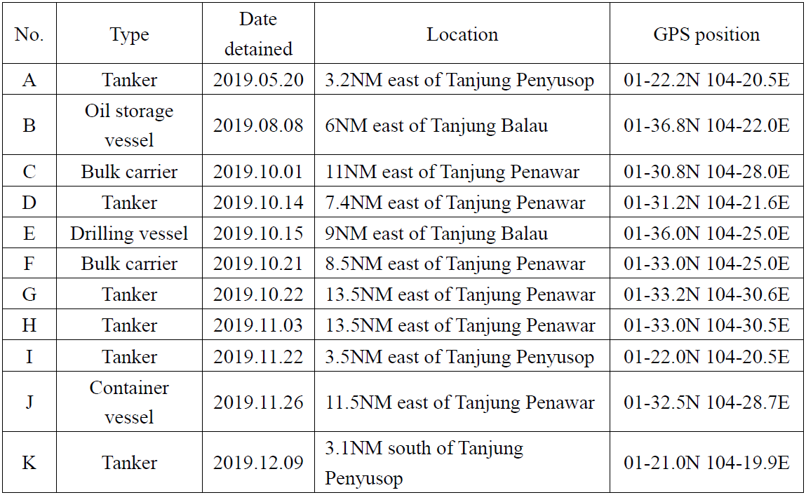
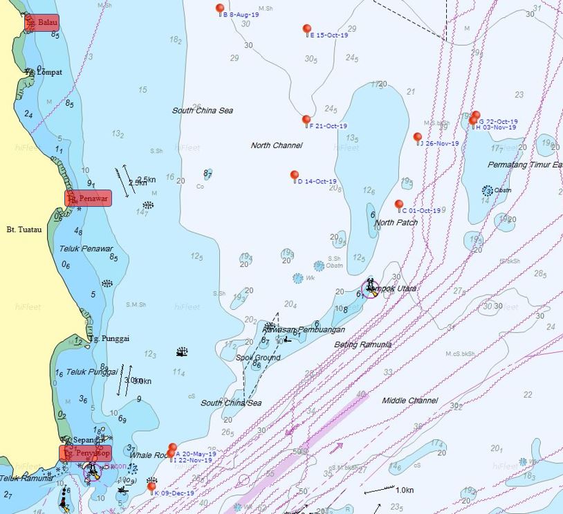
MMEA has been strengthening its law enforcement efforts in recent years, targeting not only ships bunkering in the anchorage, but also ships anchoring without permission. According to the data released on its official website, most vessels were detained in October and November, basically in three different locations, for violating Section 491B (1) (L) of the Merchant Shipping Ordinance 1952.


II. Laws and regulations of Malaysia
It’s provided in Section 491B (1) (L) of the Merchant Shipping Ordinance 1952 and Malaysia Shipping Notice MSN 05/2014 that any ship in Malaysian waters which is engaged or intends to engage in any activities below shall be required to notify the Director of Marine. The activities are:
a. dredging; b. mining, including exploration and exploitation; c. cable and pipe laying; d. marine construction, including the construction of jetties and wharves; e. dumping of any material; f. sport, leisure or recreational activity; g. survey; h. cleaning, including cleaning of cargo tanks; i. transportation, discharging or loading of wastes; j. pilotage; k. ship-to-ship activity; l. any other activity as determined by the Director of Marine: i. laying up, ii. welding and other hot works, iii. anchoring in a non-anchorage areas, and iv. any form of underwater operation.
The notification to the Director of Marine at the nearest Port Office shall be made using the prescribed form during normal working hours through email, facsimile or in person not later than 24 hours before the activity is scheduled to commence. Please note that the Director of Marine may refuse to grant approval or may impose such terms and conditions as he thinks fit upon receiving the said notification.
If notification is not given accordingly, the owner or agent of the ship shall be guilty of an offence and shall, on conviction, be liable to a fine not exceeding one hundred thousand ringgit (~USD$ 24k) or to imprisonment for a term not exceeding 2 years or to both. In addition, the Malaysian authority has the power to detain any vessel that fails to give notification under the MSN 5/2014.

III. Baseline of Malaysia territorial sea
Malaysia joined the United Nations Convention on the Law of the Sea 1982 on November 14, 1996 and promulgated the Baselines of Maritime Zones Act 2006 and Territorial Sea Act 2012. The Malaysian government claimed that the method of straight baselines may be employed, and the breadth of the territorial sea shall be 12 nautical miles. However, the baseline of its territorial sea has never been announced. This may be an important reason why occasionally there are ships being detained – the master can’t tell whether the location which he intends to drop anchor is within Malaysian waters.
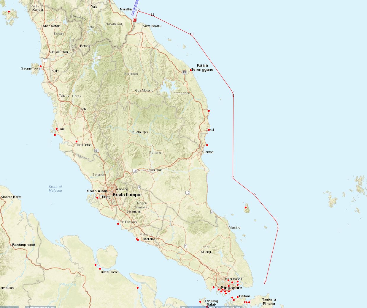
Malaysia once in 1979 issued a new map of West Peninsular Malaysia and East Sabah & Sarawak which illustrates claims to Malaysian territorial waters in dark blue, resulting in the opposition of the international community, especially neighboring countries. It is also against its commitment when it joined the United Nations Convention on the Law of the Sea 1982 in 1996. However, the map No. R97 (Peta Sempadan Perairan Pelantar Benua Malaysia (1:1 500 000) – No. Siri Rampaian 97) is still available on Malaysian Bureau of Surveying and Mapping official website (https://www.jupem.gov.my/page/miscellaneous-map). The map contains information on continental shelf boundaries, international boundary lines, and territorial waters, and may be the basis of MMEA when investigating whether ships have illegally entered its territorial waters for anchoring and operations.
Furthermore, the Club noticed that two ships were detained 13 nautical miles east of Johor coast in October 2019, and recently on January 5, 2020, 26 nautical miles west of MUKA Cape, Penang Island, Malaysia’s declared territorial waters, a Singapore-flagged tanker was detained – without doubt for previously explained reasons.

IV. Malaysia Johor east coast border
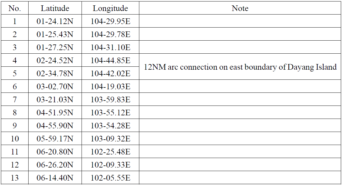
Referring to No. R97, the Club has dotted down several connection points along Johor east coast border in the table below.

V. Advice to Members
Ships intending to drop anchor in Malaysian waters east of the Strait of Singapore, specifically in the EOPL for voyage instructions, cargo holds preparation or bunkering operations are advised to notify the Malaysia Director of Marine through the agent about the activities that are going to be carried out.
Since the coordinates of the baseline for Malaysia’s territorial sea are not known, once a vessel is within Malaysian territorial waters and if the Master is not sure whether the location which he intends to drop anchor is a designated anchorage area, he should, out of prudence, and as a matter of priority, liaise with the local shipping agent to contact the Malaysia Marine Department to ascertain this point, or keep as far as possible away from Malaysian waters (away from the aforementioned border line). Also, keep away from the main channel and beware of obstructions like underwater cables.
In addition to Malaysian waters in the EOPL, ships should try to avoid entering any other territorial waters of Malaysia for anchoring or other operations unless with approval by the Malaysian authorities, especially in the waters of Malacca in north Malaysia. Ship operations in the area have also been closely monitored by MMEA with frequent occurrence of detentions.
For more information, please contact your manager at the Club.
